")
")
The GR20 is a mythical long distance hiking trail that crosses the island of Corsica diagonally, from Calenzana in the North, to Conca in the South.
The 200km trail follows the granite backbone of mountains that divides the island in two, many of which soar above 2000m altitude. The GR20 is the best and toughest long distance hike in Europe !
I made my first GR20 in 2011 and promised myself to make it again with my son for my 60th birthday. So in 2017, i planned it and here are few advices. We made it in 10 days.
If you find this anything of helpful, please leave a post..
My GR20 check-list
Here is a checklist i've made for my 2nd GR20. It might be useful...
Download the checklist in different formats : PDF or ODS . The one in ODS allows you to add the weights of packed things and to get the total weight in your rucksack.
Some advices :
- never hike alone but with someone that has the same level and you know well ! You can than share joys, sorrows and the package.
- never start a long hike with new or few used shoes. At first to make them at you feets, and second to discover their flaws.
- test all your equiment in real conditions BEFORE the start.
- your feet are your insurance to finish the GR20 !! Prepare them by massaging them every day during 3 weeks with AKILEINE NOK ointment (or equivalent) and every morning alone the trail. Zero blisters !
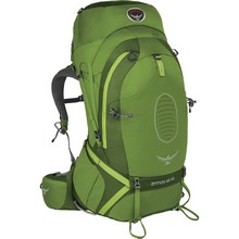
- choose a rucksack large enough to load everything in it. (65 l for my own, 45 l during my 1st GR20). Don't load anything outside the backpack, it will be wet if it rains, hung on rocks and imbalance you.
- travel as light as possible, carry only what is necessary ! A soap is enough for your onw hygiene and washing your clothes, a tube of toothpaste can already be started and enough for 2, etc... (see my checklist)
- learn how to load and adjust your backpack. On the GR20 i've seen almost evrything what can go wrong and i've provided advices to people that changed their life ...
- confine all your small belongings in small waterproof ZIP bags, clean closes in a large plastic bag. Have another one for dirty and wet things.
- have some safety pins with you ! They are light and can help you in MANY situations ! I use them to hang out the laundry and repair torn clothes, a tent or anything else...
- have always enough water and a complete meal in advance.
- drink a lot and permanently to avoid cramps and other problems. Certain days, we drank as much as 8 l ... (water and .... beer)
- stretch before and after each stage. Your body will thank you!
- walk your own rythm and listen to your body. Rest when necessary !
- have a good mastress and sleeping bag. They will garanty you a good and restfull night. Go to bed asap and rest as much as you can.
- use hiking sticks. They will relieve your joints a lot on the descents and prevent falls on the climbs. Learn how to use it if you've never used it before.
- respect the nature and mountain ! Do not throw anything away and pick up what is lying around. Do not wash with soap in rivers and avoid bathing with sunscreen !
- don't plan for too tight a timing. If you plan to do it in 10 days, plan on 2-3 more. The weather or the fires can block you and you will enter the red zone which pushes some to want to finish at all costs at the risk of putting themselves in danger!
- leave early to arrive early at the shelters and to get settled properly, wash your clothes, rest and also avoid the heat and thunderstorms.
- leave with enough money. The shelters do not accept credit cards and there is no cash machine, except to leave the GR20 and go to Corte.
- expect to spend more money than you think. "On the GR, everything is expensive".
- be ready to face the rusticity and sometimes even the unsanitary conditions of the "toilets" and "showers". The GR20 is not made for the delicate !
- do not listen (too much) to the advices of other hikers about the next stage and the times given. Anyway, 10 hikers will give you 10 different opinions for the same stage!
- REQUIRE receipts for your bivouac payments in order to stop the fraudulent practices of certain "pseudo-keepers".
- the cellphone network is very hazardous. The french SFR network is better in the mountains than the Orange one.
- and finally, take the time to enjoy the landscapes and the best that Corsica has to offer! This will make up for everything else ...
GR20 stages
I've made the altimetric profiles and the maps of each stage using the tools offered on the geoportail site and this one. My maps can replace a guidebook. You can throw (or donate) a page every day ...I've made 2 files with all stages of the GR20 Nord and GR20 South.
Below, all files individually.
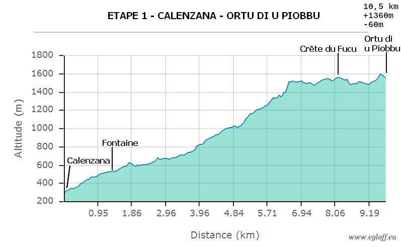
Stage 1 : Calenzana -> Ortu di u Piobbu
 |
 |
| Altimetric profile | Map PDF format |
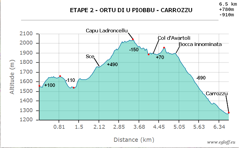
Stage 2 : Ortu di u Piobbu - Carrozzu
 |
|
| Altimetric profile | Map PDF format |
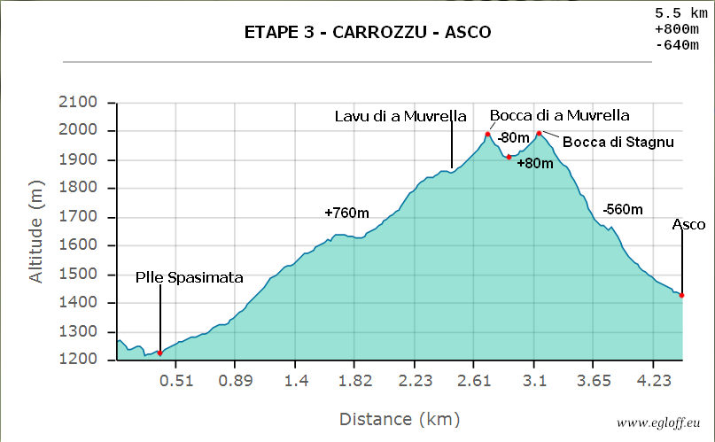
Stage 3 : Carrozzu -> Asco
 |
|
| Altimetric profile | Carte au format PDF |
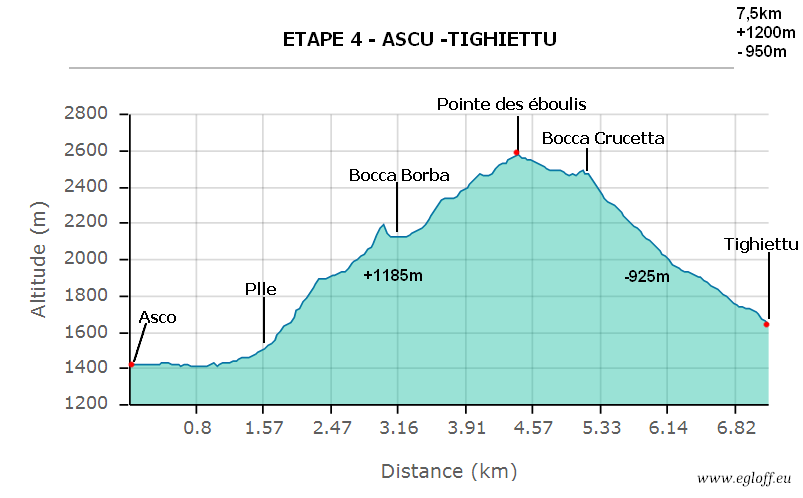
Stage 4 : Asco -> Tighiettu
 |
|
|
| Altimetric profile | Map PDF format |
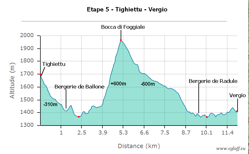
Stage 5 - Tighiettu -> Vergio
 |
|
| Altimetric profile | Map PDF format |
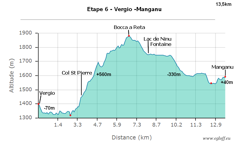
Stage 6 - Vergio -> Manganu
 |
|
| Altimetric profile | Map PDF format |
Stage 7 : Manganu -> Pietra piana
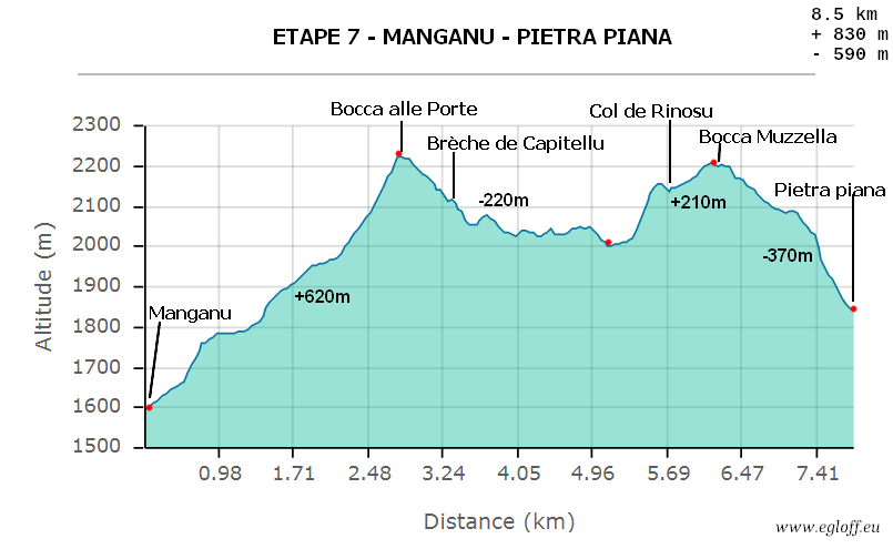 |
|
| Altimetric profile | Map PDF format |
Stage 8 : Pietra piana -> Onda
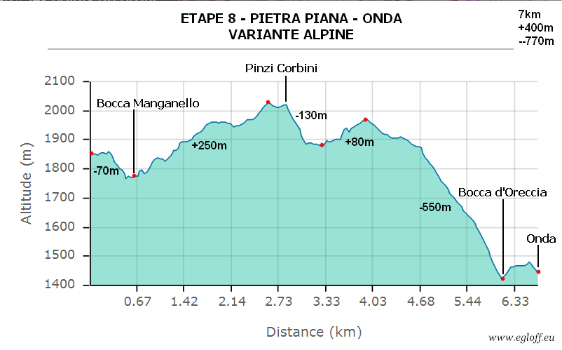 |
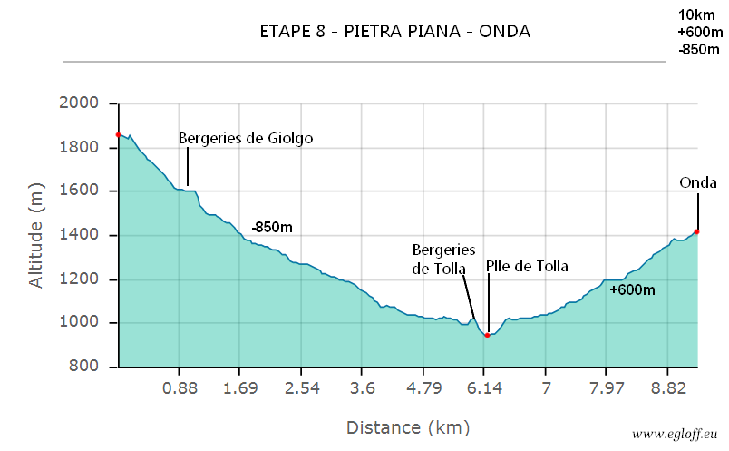 |
|
| Altimetric profile, varian stage | Normal tage - Altimetric profile | Map PDF format |
Stage 9 : Onda -> Vizzavona
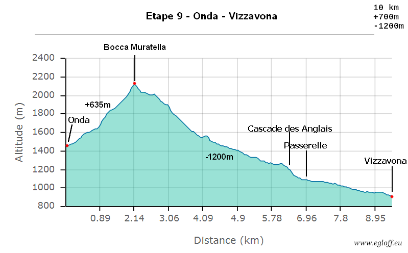 |
|
| Altimetric profile | Map PDF format |
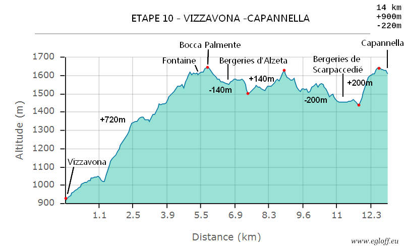
Stage 10 : Vizzavona -> Capanella
 |
|
| Altimetric profile | Map PDF format |
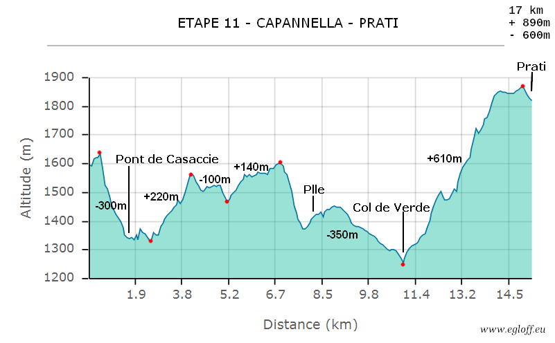
Stage 11 : Capannella -> Prati
 |
|
| Altimetric profile | Map PDF format |
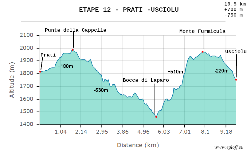
Stage 12 : Prati -> Usciolu
 |
|
| Altimetric profile | Map PDF format |
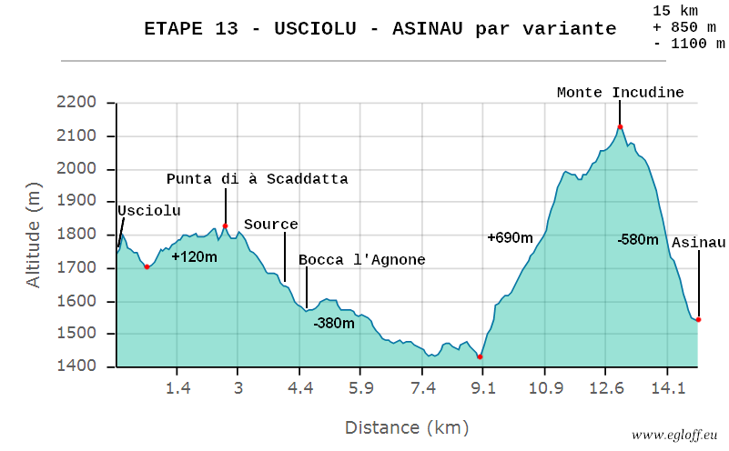
Stage 13 : Usciolu -> Asinau
 |
|
| Profil altimétrique | Map PDF format |
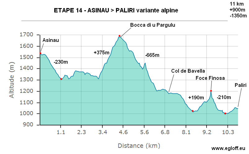
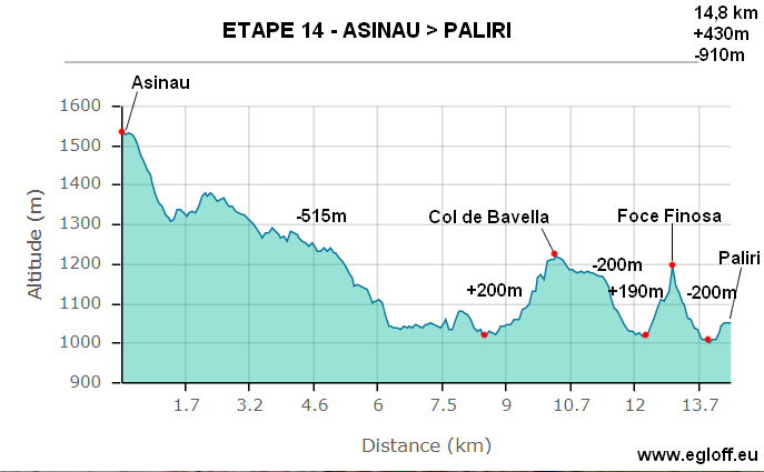
Stage 14 : Asinau -> Paliri
 |
 |
|
| Altimetric profile alpine stage | Altimetric profile normal stage | Map PDF format |
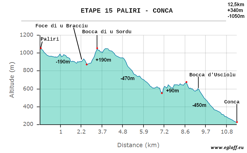
Stage 15 : Paliri -> Conca
 |
|
| Altimetric profile | Map PDF format |
Leave a post if you've found anything usefull ... Thanks and enjoy.